Sale agreed? Before you sign
Check any house in Ireland before you buy it.
Flood zone, radon, planning files, BER, what it last sold for: thirty-eight checks from the official Irish records, in ten seconds. Free snapshot first.
Or pick the house on the map. No account, nothing stored.
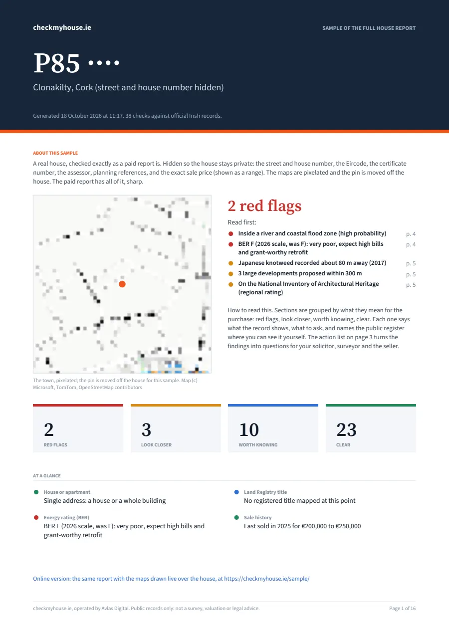
A real house, Clonakilty, Cork
2 red flags
3 more to look closer at
- Flood riskInside a river and coastal flood zone (high probability)
- Energy rating (BER)BER F (2026 scale, was F): very poor, expect high bills and grant-worthy retrofit
- Knotweed and invasive plantsJapanese knotweed recorded about 80 m away (2017)
- Planning nearby3 large developments proposed within 300 m
- Protected structures and designationsOn the National Inventory of Architectural Heritage (regional rating)
- Year built and its eraBuilt about 1860: a pre-1900 mid-terrace house, solid walls and old services
Open the sample PDF (23 pages, BER certificate inside)
or read all 38 sections on the web
What we check
Thirty-eight questions a surveyor would ask, answered from the record.
Every answer links to the public source it came from. Listed in the order they appear in the report: what can stop a mortgage first, what is nice to know last.
House or apartment
01Eircode address points per roof
What you get: Nothing red: says whether this is a house or one of N units, and flags shops underneath.
Year built and its era
02SEAI BER register, building regulations history
Red flag: Apartment built 1991 to 2013: the fire-safety and water-ingress defects era. Older houses: lead, asbestos, wiring.
Land Registry title
03Tailte Éireann registered boundaries (open data)
Red flag: Nothing red: registered or not, freehold or leasehold, the plot size, and the boundary drawn over the house.
Registered tenancy
04RTB register
Red flag: A tenancy registered at this Eircode: a tenant may be in place, selling does not end it.
Garden orientation
05Land Registry boundary and the road the house fronts
Red flag: Nothing red: which way the garden faces, a note for north-facing.
Flood risk
06OPW National Flood Maps
Red flag: Inside a river or coastal flood extent. Insurers will ask.
Coastal erosion
07OPW coastal strategy study
Red flag: Predicted 2050 shoreline within 100 m. Not insurable.
Radon
08EPA Radon Risk Map
Red flag: High Radon Area: about 1 in 5 homes above the reference level.
Defective blocks and pyrite
09Gov.ie grant schemes
Red flag: Whole county in the Defective Concrete Blocks scheme; for Fingal, Meath and Wexford only designated parts, so ask the council.
Ground and geology
10Geological Survey Ireland
Red flag: Peat, landfill or karst under the site.
Knotweed and invasive plants
11National Biodiversity Data Centre and other recorders, via GBIF
Red flag: Japanese knotweed recorded within 100 m in the last ten years: lenders ask for a management plan.
Management company (OMC)
12CRO company register
Red flag: The block's management company dissolved or listed for strike-off: lenders walk away.
Sewer or septic tank
13EPA waste water register
Red flag: Septic tank on ground that drains poorly, or a town plant still discharging raw sewage.
Energy rating (BER)
14SEAI National BER Register
Red flag: E, F or G: budget for insulation and heating.
Noise
15EPA strategic noise maps
Red flag: 70 dB Lden or more from a motorway, railway or runway.
Air quality
16EEA annual maps, EPA street model in Dublin
Red flag: PM2.5 or NO2 above the 2030 EU limit: smoke or traffic.
Industry and waste nearby
17EPA licence registers, GSI quarries
Red flag: Licensed plant, waste site, quarry or old landfill within 500 m.
Power lines and substations
18OpenStreetMap power network
Red flag: A 110, 220 or 400 kV pylon line within 300 m: view, crackle in damp weather, and buyers who walk away at resale.
Planning on this property
19National planning register, Building Control (BCMS)
Red flag: Retention refused: something built without permission that the council would not regularise.
Planning nearby
20National planning register
Red flag: A data centre, quarry, mast, wind farm, warehouse or apartment scheme proposed within 300 m.
Zoning
21MyPlan.ie development plans
Red flag: Industrial or enterprise zoning next door.
Derelict sites
22Council Derelict Sites Registers (Dublin City, DLR, South Dublin, Roscommon)
Red flag: The house itself on the register: a 7% yearly levy and the council able to buy it compulsorily.
Protected structures and designations
23NIAH, Sites and Monuments Record, NPWS
Red flag: The house is on the architectural inventory: protected-structure rules and costs.
Property tax (LPT)
24Revenue bands 2026 to 2030
What you get: Nothing red: the yearly bill for the asking price, with your council's adjustment.
Buying costs and schemes
25Revenue, Tailte Éireann, First Home Scheme
Red flag: Nothing red: stamp duty and the Land Registry fee for the price, and whether Help to Buy and the First Home Scheme fit this house.
Sale history
26Property Price Register
Red flag: Three sales in six years.
Local prices and rents
27Property Price Register, RTB Rent Index
Red flag: Nothing red: the 12-month median around the house, the trend, and what it would rent for.
Crime and Garda station
28CSO recorded crime by station
Red flag: Incidents up 25% on the five-year average.
Neighbourhood profile
29Census 2022, Pobal HP index
Red flag: Nothing red: owner-occupation, education, jobs and the Pobal affluence score for the division.
Homes on this street
30Census 2022 small area (CSO)
Red flag: Nothing red: what the block is built of and when, who owns and who rents, heating, water and sewer, and how many homes stand empty.
River and bathing water quality
31EPA Water Framework Directive status, beaches.ie
Red flag: The river at the end of the garden rated Bad or Poor: smell, algae and sewage upstream.
Broadband
32ComReg operator data, NBI map
Red flag: No wired operator at the address: 4G or Starlink only.
Mobile signal
33ComReg coverage map
Red flag: No solid 4G from any of the three networks: calls only over wifi.
Mobile masts
34ComReg Site Viewer
Red flag: Nothing red: the nearest licensed mast, whose it is, how many within 500 m, and whether ComReg measured emissions nearby.
Public transport
35NTA timetables
Red flag: No bus stop within 800 m and no rail within 2 km.
Commute
36Azure Maps routing, typical traffic
Red flag: Over an hour to the nearest city or county town at 8:15 on a Tuesday.
Schools
37Department of Education
Red flag: No school within walking distance.
Shops and services
38OpenStreetMap
Red flag: No shop, pharmacy or park within a kilometre.
The full report, €19.99 once
All thirty-eight checks written out, the official record linked under each one, flood, radon and noise drawn over the house, the planning history of the house itself with what building control says was started and finished, every planning file and sale nearby, and the route to the Land Registry folio for this type of title.
One house, one payment, no account. The snapshot stays free.
No Eircode to hand?
Click the roof.
Zoom to the street and click the house. Flood, radon, noise, planning, zoning and schools work from the point alone. BER and sale history need the Eircode, so add it later if you have it.
How it works
Step 1
Find the Eircode
It is on the Daft or MyHome listing, usually under the address. No Eircode? Click the roof on the map instead.
Step 2
Thirty-eight checks run at once
All against Irish public records: OPW flood and coastal maps, EPA radon and noise, GSI ground maps, the planning register, MyPlan zoning, SEAI, Revenue, CSO crime, ComReg broadband, the Price Register.
Step 3
Read the flags first
Sections are ordered by how much they change the decision. Red means ask the seller or your surveyor; green means the public record came back clear.
Questions
- Where does the information come from?
- From Irish public records that anyone can consult: OPW flood maps, EPA radon, noise and air quality maps, the planning registers and the building-control register, MyPlan zoning, Revenue LPT tables, the Property Price Register, CSO crime statistics, the ComReg and NBI broadband checkers and Department of Education school lists. We put what they say about one address on one page.
- Is it free?
- The snapshot is free and needs no account: it runs all thirty-eight checks and shows how many came back red, amber or worth knowing, with four everyday checks open in full (the address, public transport, shops and services, buying costs). Which checks flagged, and what the record says, is in the full report. The full report is €19.99 for one house, paid once by card. It writes out every check, tells you where to confirm each line on the official public map or register, shows the flood, radon and noise maps over the house, and lists the planning history of the house itself, with what the building-control register says was started and signed off, every planning file nearby and every sale. The link keeps working, no login.
- How do I verify a red flag?
- Every check in the full report has a Check it yourself list: the official public map or register to open and what to search for there. You get the same answer from the source directly. Flood, radon and noise are also shown as maps over the house, so you see the zone boundary, not just our word for it.
- Can I get a refund?
- If we matched the wrong house or a check we charged for gave nothing, email hello@checkmyhouse.ie within 14 days and we refund. Because the report is delivered instantly, there is no refund once it has been opened for the right address; the free snapshot exists so you can see what is flagged before you pay.
- Is this a survey?
- No. It tells you what the public record says about the location. It cannot see damp, wiring or the roof. Use it to decide which questions to ask the seller and the surveyor, and whether to bid at all.
- What does a red flag mean?
- The public record places the house inside a zone or above a threshold that usually matters to lenders, insurers or your health: a medium-probability flood extent, a High Radon Area, 70 dB of traffic noise, an E to G energy rating. It is a reason to look closer, not a verdict on the house.
- Why does the flood check say clear when the road floods every winter?
- OPW maps cover river and coastal flooding in studied catchments. Surface water from blocked drains, small streams and groundwater are not mapped. Ask neighbours and check the OPW past flood events layer.
- Why is there no BER or sale history when I click the map?
- Those two registers list houses by Eircode or address, not by coordinates. Add the Eircode and the checks fill in.
- Do you store what I search?
- No. The Eircode or point is looked up and the result comes back to your screen. Results are cached anonymously for a few hours so repeat checks are quick.
- Is checkmyhouse.ie connected to the OPW, EPA or SEAI?
- No. It is an independent tool that puts public information in one place. Names and data remain theirs.
Check the area first
The record for every county and 200 towns, free.
- Flood maps and flood risk by county and town OPW record: 959 of 1,069 towns have a recorded flood nearby
- Radon map by county and town EPA map: 36% of towns sampled are in a High Radon Area
- Planning permission and applications by county and council how to search each council's register, three years of applications, largest schemes
- BER ratings by county and town SEAI register: 12% of certified homes are E, F or G
- Japanese knotweed by county public sighting records
- BER check by Eircode find the certificate and advisory report for one address
- Eircode finder on a map click the roof, get the Eircode and address
Guides for buyers
What to read at sale agreed.
- BER Exempt: What It Means on a Listing and What to Ask
- Solicitor Fees When Buying a House in Ireland (2026)
- Land Registry Fees Ireland: Transfer, Mortgage, Folio, Map
- How to Search Planning Applications in Ireland: 3 Registers
- Derelict Sites Register Ireland: Levy, Search, Buying One
- BER Certificate Ireland: Cost, Validity, How to Get One
- New planning exemptions 2026: what a buyer should check
- Buying a house with a septic tank in Ireland: what to check
- Land Registry Ireland: Landdirect Folio Search for €5
- Sale agreed in Ireland: what happens next and what to check
- BER Rating Check: By Eircode or BER Number (SEAI Register)
- Is My House in a Flood Zone? OPW Maps and Insurers Explained
- Radon when buying a house in Ireland: map, test, cost
- Japanese knotweed in Ireland: spotting it, lenders, cost
- BER for buyers: certificate, advisory report, 2026 scale
- Mica and pyrite before buying: counties, years, questions
- Planning search before buying a house: 3 files that matter
- Property Price Register explained: what it shows and hides
- 20 questions to ask when viewing a house in Ireland
- What a surveyor checks in Ireland, and what they do not
- LPT after the 2026 revaluation: what a buyer inherits
- All guides
Planning permission by county
How to search the planning register where you are buying.
Each county page explains how to search that council’s register, lists three years of applications by town and the largest schemes on file, and links the national map and MyPlan zoning.
- Planning permission in Co. Carlow
- Planning permission in Co. Cavan
- Planning permission in Co. Clare
- Planning permission in Co. Cork
- Planning permission in Co. Donegal
- Planning permission in Dublin
- Planning permission in Co. Galway
- Planning permission in Co. Kerry
- Planning permission in Co. Kildare
- Planning permission in Co. Kilkenny
- Planning permission in Co. Laois
- Planning permission in Co. Leitrim
- Planning permission in Co. Limerick
- Planning permission in Co. Longford
- Planning permission in Co. Louth
- Planning permission in Co. Mayo
- Planning permission in Co. Meath
- Planning permission in Co. Monaghan
- Planning permission in Co. Offaly
- Planning permission in Co. Roscommon
- Planning permission in Co. Sligo
- Planning permission in Co. Tipperary
- Planning permission in Co. Waterford
- Planning permission in Co. Westmeath
- Planning permission in Co. Wexford
- Planning permission in Co. Wicklow
- Planning permission in Dublin City Dublin City Council
- Planning permission in Fingal Fingal County Council
- Planning permission in Dún Laoghaire-Rathdown Dún Laoghaire-Rathdown County Council
- Planning permission in South Dublin South Dublin County Council
- Planning permission in Cork City Cork City Council
- Planning permission in Galway City Galway City Council